The function of "people in the vicinity" is not unfamiliar. Similar functions were first contacted by maps applications, such as searching nearby cinemas, supermarkets and so on. Nevertheless, it is the function of Wechat "people around" that really makes the nearby people popular in the north and south of the Yangtze River. When Wechat just came out, there was another saying in the workshop, "Lonely girls chat and play with Wechat, lonely men search nearby".
v Preparations
Create a test database
CREATE TABLE `userposition` (
    `id` int(10) unsigned NOT NULL AUTO_INCREMENT,
    `city` varchar(20) NOT NULL,
    `position` varchar(128) NOT NULL,
    `longitude` decimal(18,15) NOT NULL,
    `latitude` decimal(18,15) NOT NULL,
    PRIMARY KEY (`id`)
)ENGINE=InnoDB AUTO_INCREMENT=1 DEFAULT CHARSET=utf8;
insert into `userposition` values(1,'Beijing City','HUILONGGUAN NEW VILLAGE CENTRAL DISTRICT', 116.310771,40.06263);
insert into `userposition` values(2,'Beijing City','Jinyu Washington', 116.310127,40.064379);
insert into `userposition` values(3,'Beijing City','Rongze Jiayuan Central District', 116.311962,40.064822);
insert into `userposition` values(4,'Beijing City','Huilong Guanxincun East District', 116.312541,40.063246);
insert into `userposition` values(5,'Beijing City','Upper east side', 116.314168,40.033075);
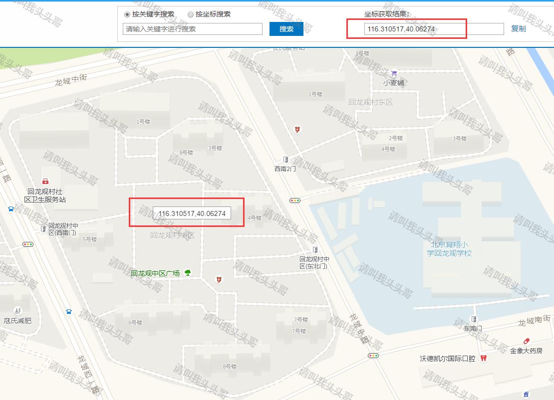
The longitude and latitude of the test data can be used Gould map perhaps Baidu Maps Extraction.
People near v
principle
Firstly, four points of the rectangle around a coordinate position are calculated, and then longitude and latitude are used to directly match the records in the database.
thinking
Firstly, the coordinate range of "1000 meters near a given coordinate" is calculated. Although it is a circle, we can first find the circumferential square of the circle, and then search the database with the latitude and longitude range of the square. The circle is the required search range and the square is the indirect result range.

Let's first find the boundaries of the East and west. In haversin's formula, let 1 = 2, we can get

Java implementation
/**
     * Find people nearby
     * @param radii Radius Distance (Unit km)
     * @param lon longitude
     * @param lat latitude
     * @return
     */
    @GetMapping("/nearby")
    public List<UserPosition> getVicinity(double radii, double lon, double lat){
        double r = 6371;//Earth radius kilometers
        double dis = radii;
        double dlng =  2*Math.asin(Math.sin(dis/(2*r))/Math.cos(lat*Math.PI/180));
        dlng = dlng*180/Math.PI;//Angle to radian
        double dlat = dis/r;
        dlat = dlat*180/Math.PI;
        double minlat =lat-dlat;
        double maxlat = lat+dlat;
        double minlng = lon -dlng;
        double maxlng = lon + dlng;

        return userService.getVicinity(BigDecimal.valueOf(minlng), BigDecimal.valueOf(maxlng), BigDecimal.valueOf(minlat), BigDecimal.valueOf(maxlat));
    }
mybatis
<select id="getvicinity" resultMap="BaseResultMap"> select <include refid="Base_Column_List" /> from userposition where longitude >= #{minlng} and longitude <= #{maxlng} and latitude >= #{minlat} and latitude <= #{maxlat} </select>
List<UserPosition> getvicinity(@Param("minlng") BigDecimal minlng,
                                  @Param("maxlng") BigDecimal maxlng,
                                  @Param("minlat") BigDecimal minlat,
                                  @Param("maxlat") BigDecimal maxlat);
Testing effect
Find the longitude and latitude of Huilong New Village on the map, and then test it.


v sorted by distance
Java code
 /**
     * Sort of people nearby
     * @param lon longitude
     * @param lat latitude
     * @return
     */
    @GetMapping("/nearbysort")
    public List<UserPosition> getVicinitySort(double lon, double lat){

        return userService.getvicinitysort(BigDecimal.valueOf(lon), BigDecimal.valueOf(lat));
    }
mybatis code
<select id="getvicinitysort" resultMap="BaseResultMap">
    SELECT id, city, position, longitude,latitude,
        (POWER(MOD(ABS(longitude - #{longitude}),360),2) + POWER(ABS(latitude - #{latitude}),2)) AS distance
        FROM `userposition`
        ORDER BY distance LIMIT 20
  </select>
List<UserPosition> getvicinitysort(@Param("longitude") BigDecimal longitude,
                                   @Param("latitude") BigDecimal latitude);
Testing effect

Plus, if you need to sort by distance, and return the field of distance. It can be implemented in the following way.
SELECT
    *,
    ROUND(
        6378.138 * 2 * ASIN(
            SQRT(
                POW(
                    SIN(
                        (
                            $latitude * PI() / 180 - latitude * PI() / 180
                        ) / 2
                    ),
                    2
                ) + COS($latitude * PI() / 180) * COS(latitude * PI() / 180) * POW(
                    SIN(
                        (
                            $longitude * PI() / 180 - longitude * PI() / 180
                        ) / 2
                    ),
                    2
                )
            )
        ) * 1000
    ) AS distance
FROM
    userposition
ORDER BY
    distance ASC
v Blog Summary
If the amount of data is large, you can also consider implementing people nearby based on Redis.
Other references:
- According to a given longitude and latitude point, query the location of 500 meters nearby uuuuuuuuuuuuu https://yq.aliyun.com/ziliao/230566
- Calculating the Distance between Longitudes and Latitudes of Two Points under mysql https://www.cnblogs.com/sandea/p/4673297.html
- MYSQL creates a function to calculate longitude and latitude distances http://xigua366.iteye.com/blog/2242818
Author: Please call me Brother Chief
Origin: http://www.cnblogs.com/toutou/
About the author: Focus on the project development of the basic platform. If you have any questions or suggestions, please give me more advice.
Copyright Statement: Copyright of this article is shared by the author and the blog park. Reproduction is welcomed, but this statement must be retained without the author's consent, and a link to the original text is given in a clear place on the article page.
I hereby declare that all comments and personal letters will be answered at the first time. We also welcome people in the garden to correct their mistakes and make progress together. perhaps Direct personal trust I
Support Blogger: If you think the article is helpful to you, you can click on the bottom right corner of the article. Recommend A bit. Your encouragement is the author's greatest motivation to stick to original and continuous writing!