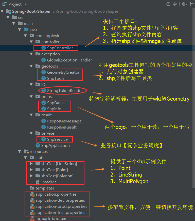
I. Project Directory Structure Tree
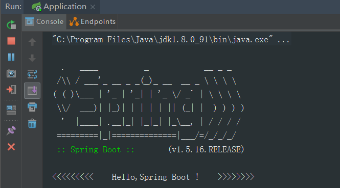
II. Project Start-up
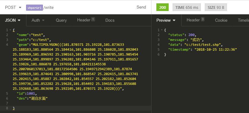
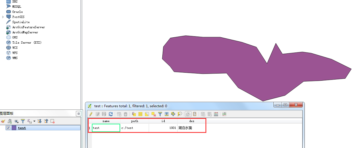
3. Write to the specified shp file
(1) json data [Post]
{
    "name":"test",
    "path":"c:/test",
    "geom":"MULTIPOLYGON(((101.870371 25.19228,101.873633 25.188183,101.880564 25.184416,101.886808 25.186028,101.892043 25.189969,101.896592 25.190163,101.903716 25.190785,101.905454 25.193464,101.899897 25.196202,101.894146 25.197911,101.891657 25.19826,101.886078 25.197658,101.884211145538 25.2007060137013,101.88172564506 25.1949712942389,101.87874 25.199619,101.874641 25.200998,101.868547 25.202415,101.863741 25.202415,101.85887 25.202842,101.854557 25.202182,101.852604 25.199736,101.852282 25.19628,101.854492 25.194183,101.855608 25.192668,101.863698 25.192105,101.870371 25.19228)))",
    "id":1001,
    "des":"Lake surface"

}
(2) Interface call
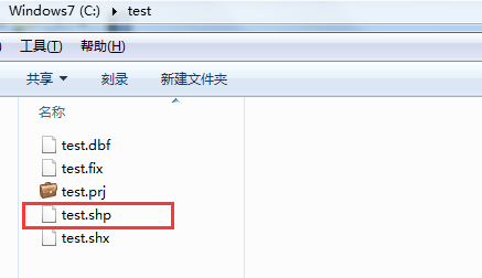
(3) QGIS view to verify data validity
4. Read the specified shp file and display the content
(1) Interface call

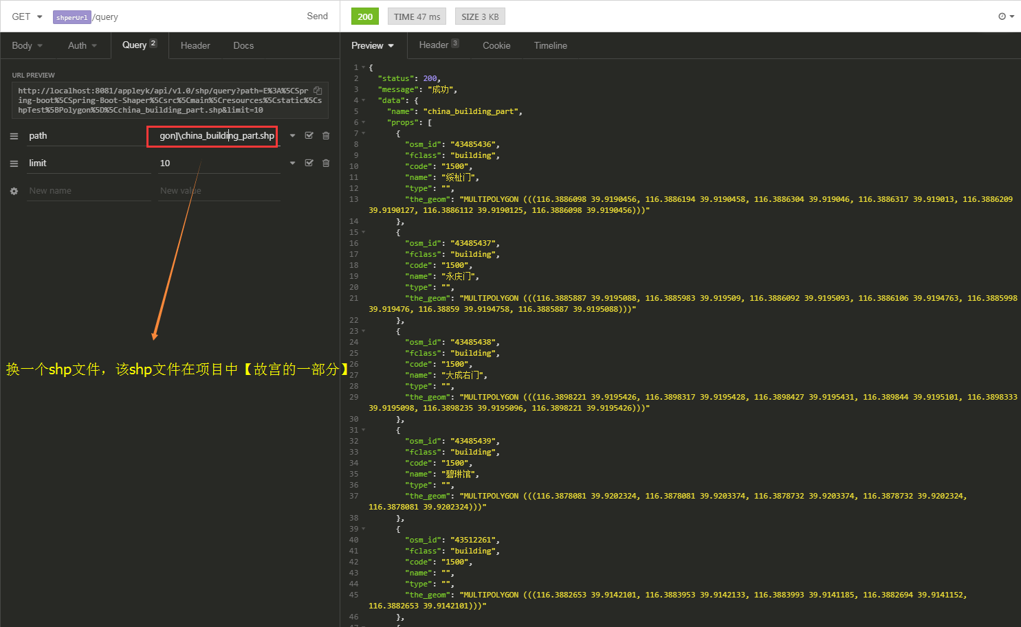
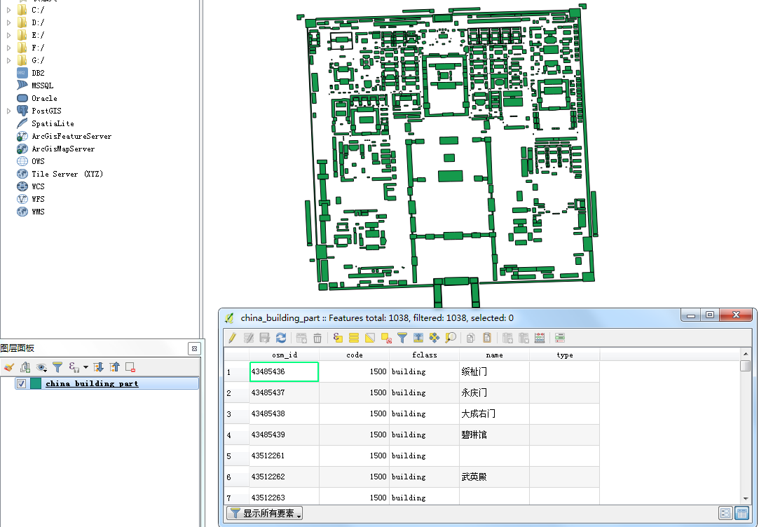
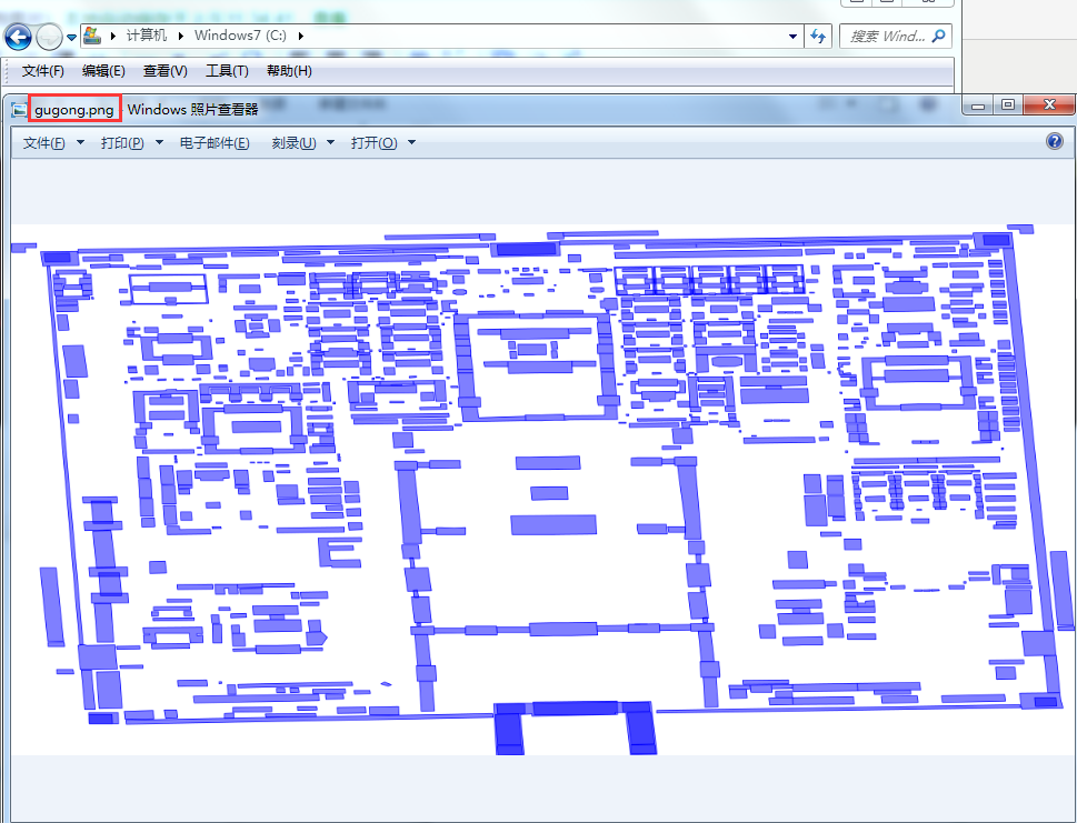
(2) QGIS displays Beijing Palace Museum [shp files in the static folder of the project]
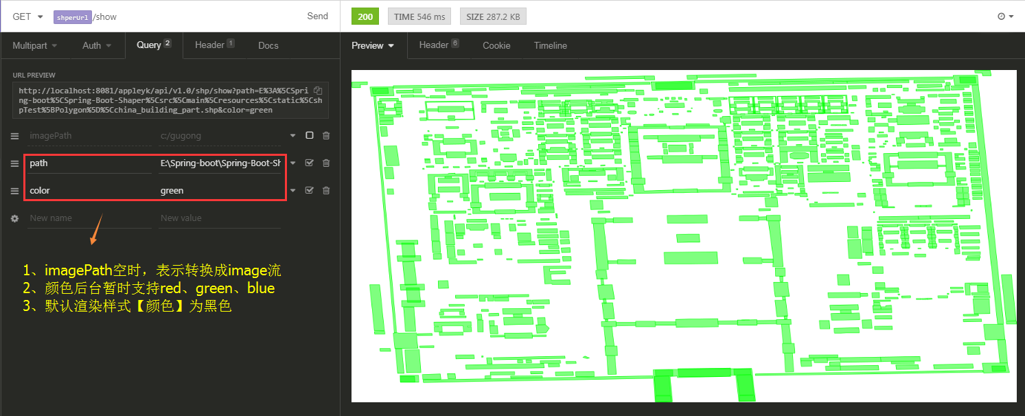
5. Converting a specified shp file to an image file or stream
(1) Interface call ==== Transfer image [png] file
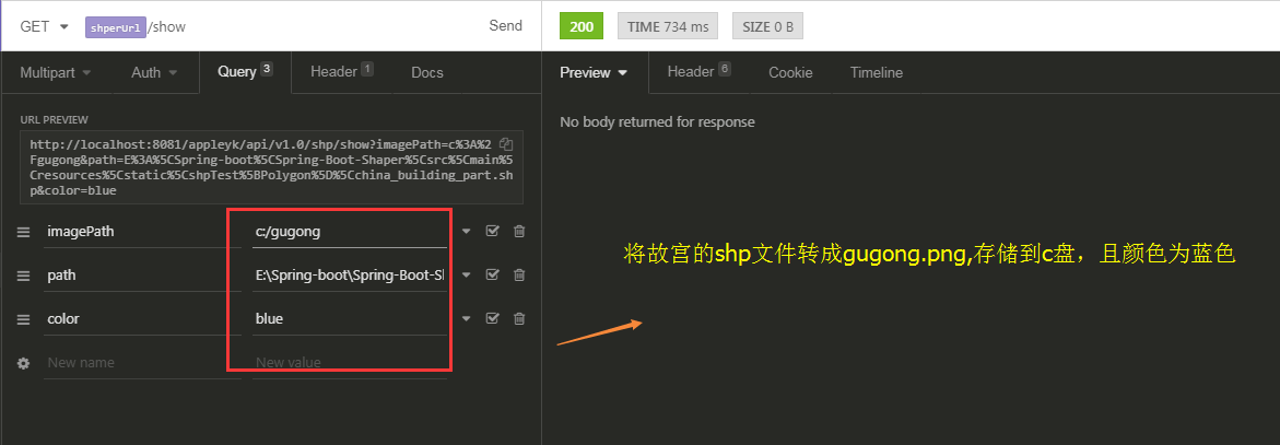
View under CD
(2) Interface call ==== image stream, output to client
6. Core Tools
package com.appleyk.geotools;

import com.appleyk.IO.StringTokenReader;
import com.appleyk.pojos.ShpDatas;
import com.appleyk.pojos.ShpInfo;
import com.appleyk.result.ResponseMessage;
import com.appleyk.result.ResponseResult;
import com.vividsolutions.jts.geom.*;
import com.vividsolutions.jts.geom.Point;
import com.vividsolutions.jts.geom.Polygon;
import org.geotools.data.*;
import org.geotools.data.shapefile.ShapefileDataStore;
import org.geotools.data.shapefile.ShapefileDataStoreFactory;
import org.geotools.data.simple.SimpleFeatureSource;
import org.geotools.feature.FeatureCollection;
import org.geotools.feature.FeatureIterator;
import org.geotools.feature.simple.SimpleFeatureTypeBuilder;
import org.geotools.geometry.jts.ReferencedEnvelope;
import org.geotools.map.FeatureLayer;
import org.geotools.map.Layer;
import org.geotools.map.MapContent;
import org.geotools.referencing.crs.DefaultGeographicCRS;
import org.geotools.renderer.lite.StreamingRenderer;
import org.geotools.styling.SLD;
import org.geotools.styling.Style;
import org.geotools.swing.JMapFrame;
import org.geotools.swing.data.JFileDataStoreChooser;
import org.opengis.feature.Property;
import org.opengis.feature.simple.SimpleFeature;
import org.opengis.feature.simple.SimpleFeatureType;
import org.springframework.util.ResourceUtils;

import javax.imageio.ImageIO;
import javax.servlet.http.HttpServletResponse;
import java.awt.*;
import java.awt.image.BufferedImage;
import java.io.File;
import java.io.IOException;
import java.io.Serializable;
import java.nio.charset.Charset;
import java.util.Collection;
import java.util.HashMap;
import java.util.Map;

/**
 * <p>shapefile Reading and Writing Tool Class </p>
 * @author Appleyk
 * @blob https://blog.csdn.net/appleyk
 * @date Created on 11:54 a.m. 2018-10-12
 */
public class ShpTools {


    /**
     * Collection Object Constructor
     */
    private  static GeometryCreator gCreator = GeometryCreator.getInstance();

    /**
     * boundary
     */
    private  static ReferencedEnvelope bounds;

    // Width of canvas
    private static final int IMAGE_WIDTH = 2400;

    // The height of the canvas
    private static final int IMAGE_HEIGHT = 1200;


    /**
     * Read shp content through shp file path
     * @param filePath
     * @throws Exception
     */
    public static ShpDatas readShpByPath(String filePath,Integer limit) throws Exception {

        // A data storage implementation that allows from Shapefiles Read and write
        ShapefileDataStore shpDataStore =  new ShapefileDataStore(new File(filePath).toURI().toURL());
        // Setting Code [Preventing Chinese Scrambling]
        shpDataStore.setCharset(Charset.forName("UTF-8"));

        // getTypeNames:Get all the geographic layers, and here I just take the first one [if it's a data table, it's the name of the table].
        String typeName = shpDataStore.getTypeNames()[0];
        System.out.println("shp[Layer) Name:"+typeName);
        FeatureCollection<SimpleFeatureType, SimpleFeature> result = getFeatures(shpDataStore, typeName);

        // Iterative feature set
        FeatureIterator<SimpleFeature> iterator = result.features();

        ShpDatas shpDatas = new ShpDatas();
        shpDatas.setName(typeName);
        shpDatas.setShpPath(filePath);
        buildShpDatas(limit, iterator, shpDatas);
        iterator.close();
        return  shpDatas;
    }


    /**
     * Get feature set according to data source and layer name
     * @param shpDataStore
     * @param typeName
     * @return
     * @throws IOException
     */
    private static FeatureCollection<SimpleFeatureType, SimpleFeature> getFeatures(ShapefileDataStore shpDataStore, String typeName) throws IOException {

        // Individual references can be made through this interface shapefile,Database tables, etc. Comparisons and constraints with data storage
        FeatureSource<SimpleFeatureType, SimpleFeature> featureSource = shpDataStore.getFeatureSource(typeName);
        // One for processing FeatureCollection Utility class. Provide an access FeatureCollection Instance mechanism
        FeatureCollection<SimpleFeatureType, SimpleFeature> result = featureSource.getFeatures();
        System.out.println("Geographical elements [records]:"+result.size()+"individual");
        System.out.println("==================================");
        return result;
    }

    /**
     * Building shpDatas objects
     * @param limit
     * @param iterator
     * @param shpDatas
     */
    private static void buildShpDatas(Integer limit, FeatureIterator<SimpleFeature> iterator, ShpDatas shpDatas) {
        // Here we only iterate before limit individual
        int stop = 0;
        while (iterator.hasNext()) {
            if (stop > limit) {
                break;
            }
            // Get a feature
            SimpleFeature feature = iterator.next();
            // Extract the set of attributes in the feature
            Collection<Property> p = feature.getProperties();

            // Traversal property set
            Map<String,Object> prop = new HashMap<>();
            for (Property pro : p) {
                String key = pro.getName().toString();
                String val = pro.getValue().toString();
                prop.put(key, val);
                System.out.println("key[Field:"+key+"\t||  value[Value:"+val);
            }
            System.out.println("\n============================ Serial number:"+stop+"\n");
            shpDatas.addProp(prop);
            stop++;
        } // end Outermost layer while
    }

    /**
     * Write a geometric object into shapefile
     * @param filePath
     * @param geometry
     */
    public  static  void writeShpByGeom(String filePath, Geometry geometry) throws Exception{

        ShapefileDataStore ds = getshpDS(filePath, geometry);

        FeatureWriter<SimpleFeatureType, SimpleFeature> writer = ds.getFeatureWriter(ds.getTypeNames()[0],
                Transaction.AUTO_COMMIT);

        // Interface SimpleFeature: A fixed list of values in a known order. SimpleFeatureType Example.
        SimpleFeature feature = writer.next();
        feature.setAttribute("name", "XXXX Name");
        feature.setAttribute("path", "c:/test");
        feature.setAttribute("the_geom", geometry);
        feature.setAttribute("id", 1010L);
        feature.setAttribute("des", "XXXX describe");

        System.out.println("========= Write ["+geometry.getGeometryType()+"]Success!=========");

        // Write in
        writer.write();

        // Close
        writer.close();

        // Release resources
        ds.dispose();

    }


    /**
     * Write a geometric object into shapefile
     * @param shpInfo
     */
    public  static ResponseResult writeShpByGeom(ShpInfo shpInfo) throws Exception{

        // Special String Parser
        StringTokenReader reader = new StringTokenReader();
        // According to the geometric object wkt String, inverse solution [parsing] Geometry object
        Geometry geometry = reader.read(shpInfo.getGeom());
        // Get shp The directory [folder] where the object is located
        String path = shpInfo.getPath();
        File file = new File(path);
        if(!file.exists()){
            file.mkdir();
        }

        if(!file.isDirectory()){
            return  new ResponseResult(ResponseMessage.BAD_REQUEST,"path Not a valid folder" );
        }

        String filePath = shpInfo.getPath()+"/"+shpInfo.getName()+".shp";
        ShapefileDataStore ds = getshpDS(filePath, geometry);
        String typeName = ds.getTypeNames()[0];
        FeatureWriter<SimpleFeatureType, SimpleFeature> writer ;
        if(shpInfo.isAppendWrite()){
            // Additional Writing of Geometric Objects
            writer = ds.getFeatureWriterAppend(typeName, Transaction.AUTO_COMMIT);
        }else{
            // Overwriting Geometric Objects
            writer = ds.getFeatureWriter(typeName, Transaction.AUTO_COMMIT);
        }

        // Interface SimpleFeature: A fixed list of values in a known order. SimpleFeatureType Example.
        SimpleFeature feature = writer.next();
        feature.setAttribute("name", shpInfo.getName());
        feature.setAttribute("path", shpInfo.getPath());
        feature.setAttribute("the_geom", geometry);
        feature.setAttribute("id", shpInfo.getId());
        feature.setAttribute("des", shpInfo.getDes());

        System.out.println("========= Write ["+geometry.getGeometryType()+"]Success!=========");

        // Write in
        writer.write();

        // Close
        writer.close();

        // Release resources
        ds.dispose();

        // Return to the one created successfully shp File path
        return  new ResponseResult(ResponseMessage.OK,filePath);

    }

    /**
     * Get the configured DataStore
     * @param filePath
     * @param geometry
     * @return
     * @throws IOException
     */
    private static ShapefileDataStore getshpDS(String filePath, Geometry geometry) throws IOException {
        // 1.Establish shape File object
        File file = new File(filePath);

        Map<String, Serializable> params = new HashMap<>();

        // 2,Data classes for capturing parameter requirements URLP:url to the .shp file.
        params.put(ShapefileDataStoreFactory.URLP.key, file.toURI().toURL());

        // 3,Create a new data store [if it exists, it is not created]
        ShapefileDataStore ds = (ShapefileDataStore) new ShapefileDataStoreFactory().createNewDataStore(params);

        // 4,Define graphic information and attribute information -- SimpleFeatureTypeBuilder Constructor for Constructing Simple Characteristic Types
        SimpleFeatureTypeBuilder tBuilder = new SimpleFeatureTypeBuilder();

        // 5,Set up -- WGS84:A two-dimensional geographic coordinate reference system, using WGS84 data
        tBuilder.setCRS(DefaultGeographicCRS.WGS84);
        tBuilder.setName("shapefile");

        // add name
        tBuilder.add("name", String.class);
        // Add to shp Name of directory
        tBuilder.add("path", String.class);
        // Add a geometric object
        tBuilder.add("the_geom", geometry.getClass());
        // Add one id
        tBuilder.add("id", Long.class);
        // Add description
        tBuilder.add("des", String.class);

        // Set the feature type for this data store
        ds.createSchema(tBuilder.buildFeatureType());

        // Set encoding
        ds.setCharset(Charset.forName("UTF-8"));
        return ds;
    }

    /**
     * Open the shp file to get the map content
     * @param filePath  File path
     * @param isOpenByChoose Whether to customize opening shp file
     * @throws Exception
     */
    public static  MapContent getMapContentByPath(String filePath,boolean isOpenByChoose,String color) throws  Exception{

        File file;
        if(isOpenByChoose){
            // 1.1, Data Source Selection shp Extended type
            file = JFileDataStoreChooser.showOpenFile("shp", null);
        }else{
            // 1.2,Get the file object according to the path
            file = new File(filePath);
        }

        if(file==null){
            return null;
        }
        // 2,Get the data source of the open file
        FileDataStore store = FileDataStoreFinder.getDataStore(file);

        // 3,Setting up the encoding of data source to prevent Chinese scrambling
        ((ShapefileDataStore)store).setCharset(Charset.forName("UTF-8"));

        /**
         * Use FeatureSource to manage element data
         * Use Style (SLD) management style
         * Managing Display with Layer
         * Use MapContent to manage all map-related information
         */

        // 4,with java Object-based access to geographic information --    Elements of Simple Theory
        SimpleFeatureSource featureSource = store.getFeatureSource();

        bounds = featureSource.getBounds();

        // 5,Create mapping content and add our shapfile piece in
        MapContent mapContent = new MapContent();

        // 6,Setting the Title of the Container
        mapContent.setTitle("Appleyk's GeoTools");

        Color color1;
        if(color == null || "".equals(color)){
            color1 = Color.BLACK;
        }else if("red".equals(color)){
            color1 = Color.RED;
        }else if("green".equals(color)){
            color1 = Color.GREEN;
        }else if("blue".equals(color)){
            color1 = Color.BLUE;
        }else{
            color1 = Color.ORANGE;
        }

        // 7,Create Simple Styles [Color Fill]
        Style style = SLD.createSimpleStyle(featureSource.getSchema(),color1);

        // 8,Show [ shapfile geographic information+Style]
        Layer layer = new FeatureLayer(featureSource, style);

        // 9,Add display to map container
        mapContent.addLayer(layer);

        return  mapContent;
    }

    public  static  void showMap(MapContent mapContent){
        JMapFrame.showMap(mapContent);
    }

    /**
     * shp File to Image [Format png]
     * @param shpFilePath shp Target file
     * @param destImagePath If not, the converted image is written into the response output stream.
     * @param response Response flow
     * @throws Exception
     */
    public static void shp2Image(String shpFilePath,String destImagePath,String color, HttpServletResponse response) throws  Exception{

        // Stream renderer
        StreamingRenderer renderer = new StreamingRenderer();
        MapContent mapContent = getMapContentByPath(shpFilePath,false,color );
        renderer.setMapContent(mapContent);
        Rectangle imageBounds = new Rectangle(0, 0, IMAGE_WIDTH, IMAGE_HEIGHT);
        BufferedImage dumpImage = new BufferedImage(IMAGE_WIDTH, IMAGE_HEIGHT, BufferedImage.TYPE_INT_RGB);
        Graphics2D g2d = dumpImage.createGraphics();
        g2d.fillRect(0, 0, IMAGE_WIDTH, IMAGE_HEIGHT);
        g2d.setRenderingHint(RenderingHints.KEY_ANTIALIASING, RenderingHints.VALUE_ANTIALIAS_ON);
        renderer.paint(g2d, imageBounds, bounds);
        g2d.dispose();
        if(destImagePath == null || "".equals(destImagePath)){
            ImageIO.write(dumpImage, "png", response.getOutputStream());
        }else{
            ImageIO.write(dumpImage, "png", new File(destImagePath+".png"));
        }
    }

    public static void main(String[] args) throws  Exception{

        File file = ResourceUtils.getFile("classpath:static/shpTest[Point]/dp_tl.shp");
        // from shp Read property information in the file
        readShpByPath(file.getAbsolutePath(),10);
        System.out.println("=================Start next shp Write geometric objects in the file===================");

        // Create folders first test
        String filePath = "C:/test/test.shp";

        String pointWkt="POINT (120.76164848270959 31.22001141278534)";
        Point point = gCreator.createPointByWKT(pointWkt);

        // Polygon[Noodles]
        String polygonWkt="POLYGON ((103.859188 34.695908, 103.85661 34.693788, 103.862027 34.69259, 103.863709 34.695078, 103.859188 34.695908))";
        Polygon polygon = gCreator.createPolygonByWKT(polygonWkt);

        // LineString[Line]
        String linestringWkt="LINESTRING(113.511315990174 41.7274734296674,113.51492087909 41.7284983348307,113.516079593384 41.727649586406,113.515907932007 41.7262243043929,113.514019656861 41.7247989907606,113.512131381714 41.7250872589898,113.51138036319 41.7256637915682,113.511315990174 41.7274734296674)";
        LineString lineString = gCreator.createLineByWKT(linestringWkt);

        // MultiPolygon[Multifaceted
        String multiPolyWkt = "MULTIPOLYGON(((101.870371 25.19228,101.873633 25.188183,101.880564 25.184416,101.886808 25.186028,101.892043 25.189969,101.896592 25.190163,101.903716 25.190785,101.905454 25.193464,101.899897 25.196202,101.894146 25.197911,101.891657 25.19826,101.886078 25.197658,101.884211145538 25.2007060137013,101.88172564506 25.1949712942389,101.87874 25.199619,101.874641 25.200998,101.868547 25.202415,101.863741 25.202415,101.85887 25.202842,101.854557 25.202182,101.852604 25.199736,101.852282 25.19628,101.854492 25.194183,101.855608 25.192668,101.863698 25.192105,101.870371 25.19228)))";
        MultiPolygon multiPolygon = gCreator.createMulPolygonByWKT(multiPolyWkt);

        // Scope of Geometric Objects [Rectangular Boundary]
        Envelope envelope = polygon.getEnvelopeInternal();
        System.out.println(envelope);

        // to shp Write geometric objects in the file
        writeShpByGeom(filePath,point);
    }

}
Contact me
CSDN name: Appleyk
CSDN Blog: https://blog.csdn.net/Appleyk
This CSDN corresponds to blog posts: https://blog.csdn.net/Appleyk/article/details/83376510