Summary
It is difficult to avoid the problem of SHP file storage when using Oracle Spatial. Although there are shp2sdo tools, they are not used to it, so this paper describes how to realize shp2sql conversion with geotools.
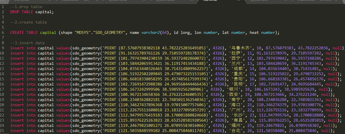
Effect
Implementation code
package com.lzugis.geotools;

import com.lzugis.CommonMethod;
import com.vividsolutions.jts.geom.Coordinate;
import com.vividsolutions.jts.geom.Geometry;
import com.vividsolutions.jts.geom.GeometryFactory;
import com.vividsolutions.jts.simplify.TopologyPreservingSimplifier;
import org.geotools.data.shapefile.ShapefileDataStore;
import org.geotools.data.simple.SimpleFeatureCollection;
import org.geotools.data.simple.SimpleFeatureIterator;
import org.geotools.data.simple.SimpleFeatureSource;
import org.geotools.factory.CommonFactoryFinder;
import org.geotools.filter.text.cql2.CQL;
import org.opengis.feature.simple.SimpleFeature;
import org.opengis.feature.simple.SimpleFeatureType;
import org.opengis.feature.type.AttributeDescriptor;
import org.opengis.feature.type.AttributeType;
import org.opengis.filter.Filter;
import org.opengis.filter.FilterFactory2;
import scala.util.parsing.combinator.testing.Str;

import java.io.File;
import java.nio.charset.Charset;
import java.util.ArrayList;
import java.util.HashMap;
import java.util.List;
import java.util.Map;
import com.lzugis.geotools.model.Fields;

public class Shp2Orcale {
    private final Map<String, String> fMap = new HashMap<>();

    private SimpleFeatureSource featureSource = null;
    private String tableName = "";
    private List<Fields> fields = new ArrayList<>();
    private CommonMethod cm = new CommonMethod();

    public Shp2Orcale(){
        fMap.put("string", "varchar2(64)");
        fMap.put("long", "long");
        fMap.put("double", "number");
        fMap.put("shape", "\"MDSYS\".\"SDO_GEOMETRY\"");
    }

    public void readShape(String shpfile){
        try {
            File file = new File(shpfile);
            ShapefileDataStore shpDataStore = null;

            shpDataStore = new ShapefileDataStore(file.toURL());
            //Set encoding
            Charset charset = Charset.forName("GBK");
            shpDataStore.setCharset(charset);
            tableName = shpDataStore.getTypeNames()[0];
            featureSource =  shpDataStore.getFeatureSource (tableName);
        }catch (Exception e){
            e.printStackTrace();
        }
    }

    public void getShpFields(){
        SimpleFeatureType schema = featureSource.getSchema();
        List<AttributeDescriptor> attrs= schema.getAttributeDescriptors();
        for(int i=0;i<attrs.size();i++){
            AttributeDescriptor attr = attrs.get(i);
            Class<?> cls = attr.getType().getBinding();
            String clsName = cls.getName();
            clsName = clsName.substring(clsName.lastIndexOf(".")+1).toLowerCase();
            Fields field = new Fields(attr.getLocalName(), clsName);
            fields.add(field);
        }
    }

    public void createTableSql(String sqlpath){
        cm.append2File(sqlpath, "--1.drop table\r\nDROP TABLE "+tableName+";");
        cm.append2File(sqlpath, "\r\n--2.create table\r\n");
        StringBuffer sql = new StringBuffer();
        sql.append("CREATE TABLE "+tableName+" (");
        for(int i=0, size = fields.size();i<size;i++){
            Fields field = fields.get(i);
            String filedname = field.getFieldmame().toLowerCase();
            filedname = filedname.equals("the_geom")?"shape":filedname;
            String fieldtype = field.getFieldtype();
            fieldtype = filedname.equals("shape")?"shape":fieldtype;
            sql.append(filedname+" "+fMap.get(fieldtype));
            if(i!=size-1) sql.append(", ");
        }
        sql.append(");");
        cm.append2File(sqlpath, sql.toString());
    }

    public void insertValueSql(String sqlpath) {
        try {
            cm.append2File(sqlpath, "\r\n--3.insert data");

            SimpleFeatureCollection result = featureSource.getFeatures();
            SimpleFeatureIterator itertor = result.features();

            StringBuffer sql = new StringBuffer();
            while (itertor.hasNext()){
                SimpleFeature feature = itertor.next();
                StringBuffer _sql = new StringBuffer();
                _sql.append("insert into "+tableName+" values(");
                for(int i=0, size = fields.size();i<size;i++){
                    Fields field = fields.get(i);
                    String filedname = field.getFieldmame();
                    filedname = filedname=="the_geom"?"shape":filedname;
                    String fieldtype = field.getFieldtype();

                    if(filedname!="shape"){
                        if(fieldtype.equals("string")){
                            _sql.append("'"+feature.getAttribute(filedname)+"'");
                        }else {
                            _sql.append(feature.getAttribute(filedname));
                        }
                    }else{
                        Geometry geom = (Geometry)feature.getAttribute("the_geom");
                        _sql.append("sdo_geometry('"+geom.toString()+"', 4326)");
                    }
                    if(i!=size-1) _sql.append(", ");
                }
                _sql.append(");\r\n");
                sql.append(_sql);
            }
            cm.append2File(sqlpath, sql.toString());
        }catch (Exception e){
            e.printStackTrace();
        }
    }

    /**
     * Tool Class Testing Method
     * @param args
     */
    public static void main(String[] args) {
        Shp2Orcale shp2orcl =new Shp2Orcale();
        String shppath = "D:\\data\\wgs84\\capital.shp";
        String sqlpath = "D:\\data\\wgs84\\sql\\capital.sql";
        try{
            long start = System.currentTimeMillis();
            //Read shp files
            shp2orcl.readShape(shppath);
            shp2orcl.getShpFields();
            shp2orcl.createTableSql(sqlpath);
            shp2orcl.insertValueSql(sqlpath);
            System.out.println("Total time consuming"+(System.currentTimeMillis() - start)+"ms");
        }
        catch(Exception e){
            e.printStackTrace();
        }
    }
}
Explain:
1. For complex lines or surfaces, sql is too long. A simplified line of code is added to the article.
Technology blog
CSDN: http://blog.csdn.NET/gisshixisheng
Online tutorials
https://edu.csdn.net/course/detail/799
https://edu.csdn.net/course/detail/7471
Contact information
| type | content |
|---|---|
| 1004740957 | |
| Public address | lzugis15 |
| niujp08@qq.com | |
| webgis group | 452117357 |
| Android group | 337469080 |
| GIS Data Visualization Group | 458292378 |
The knowledge planet of "GIS Lecture" has been opened. On the planet, I will provide one-to-one question and answer service. You ask and answer, and I look forward to meeting you.