Preface
The text and pictures of this article are from the Internet, only for learning and communication, not for any commercial purpose. The copyright belongs to the original author. If you have any questions, please contact us in time for handling.
By Mona Lippo
PS: if you need Python learning materials, you can click the link below to get them by yourself
http://note.youdao.com/noteshare?id=3054cce4add8a909e784ad934f956cef
Preface
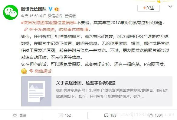
Some media exposed that wechat sent the original picture or there was a risk of leaking location information. In response, Tencent's wechat team Weibo announced in a statement on December 1 that the photos sent by the circle of friends have been automatically compressed by the system without information such as location. If you are worried, you can post them after finishing the picture, as shown in the following figure:

Wechat team mentioned Exif, what is Exif?
Exchangeable image file format (Exif) is specially set for the photos of digital cameras. It can record the attribute information and shooting data of digital photos.
Exif was originally developed by Japan Electronics Industry Development Association in 1996, version 1.0. In 1998, upgrading to 2.1 added support for audio files. In March 2002, version 2.2 was published.
Python Library
Here we need two libraries of Python, one is to read the Exif information, the other is to get the detailed address information according to the longitude and latitude of geopy;
The installation is as follows:
pip3 install exifread
pip3 install geopy
Python source code
1 import exifread 2 import json 3 import urllib.request 4 import sys 5 from geopy.geocoders import Nominatim 6 7 # Get photo details 8 def get_img_infor_tup(photo): 9 img_file = open(photo, 'rb') 10 image_map = exifread.process_file(img_file) 11 12 try: 13 #Longitude of picture 14 img_longitude_ref = image_map["GPS GPSLongitudeRef"].printable 15 img_longitude = image_map["GPS GPSLongitude"].printable[1:-1].replace(" ","").replace("/",",").split(",") 16 img_longitude = float(img_longitude[0])+float(img_longitude[1])/60+float(img_longitude[2])/float(img_longitude[3])/3600 17 if img_longitude_ref != "E": 18 img_longitude = img_longitude * (-1) 19 20 #Latitude of picture 21 img_latitude_ref = image_map["GPS GPSLatitudeRef"].printable 22 img_latitude = image_map["GPS GPSLatitude"].printable[1:-1].replace(" ","").replace("/",",").split(",") 23 img_latitude = float(img_latitude[0])+float(img_latitude[1])/60+float(img_latitude[2])/float(img_latitude[3])/3600 24 if img_latitude_ref != "N": 25 img_latitude = img_latitude*(-1) 26 27 #Time taken 28 img_create_date = image_map["EXIF DateTimeOriginal"].printable 29 30 img_file.close() 31 32 # Return latitude and longitude tuple 33 return img_longitude, img_latitude, img_create_date 34 35 except Exception as e: 36 print('ERROR:Not included in picture Gps information') 37 38 # Obtain detailed information according to latitude and longitude 39 def get_detail_infor(lat, lon): 40 reverse_value = str(lat) + ', ' + str(lon) 41 geolocator = Nominatim() 42 location = geolocator.reverse(reverse_value) 43 44 print('Longitude and latitude information of photos:') 45 print((location.latitude, location.longitude)) 46 47 print('Photo address information:') 48 print(location.address) 49 50 print('Full information of the photo:') 51 print(location.raw) 52 53 if __name__ == '__main__': 54 infor_tup = get_img_infor_tup('./image/IMG_2174.JPG') 55 get_detail_infor(infor_tup[1], infor_tup[0])